A geologist responds
Item
Title
A geologist responds
Creator
Nina Liebenberg
Date Created
2021
Type
Email
Description
"Dear Nina,
Thanks for your email - it was a lovely detour from the work I have been trying to do all afternoon. I love looking at geological maps - both old and new alike - so this was a treat.
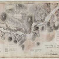
Stow's map is fantastic, right down to the amazing calligraphy. Truly a piece of scientific art. I couldn't read his name on the map properly - Did he have middle initial(s) other than 'W' or did he sign off as Geo W Stow (just curious)?
Off the bat, sadly, I am not in the UCT geo dept anymore so I can't say what materials might relate to your request. I am sure there are plenty of maps that will reference part of his original map/work (esp given it was likely in the 1880s!!). I recently went down a Du Toit rabbit hole and I know he mapped in this general area too:
Du Toit, A. L., 1907. Geological survey of the eastern portion of Griqualand West. Rep. Geol. Comm. C. G. H. for 1906, pp. 87 - 176. [no doubt this has some lovely maps - how much overlap with your study, I am not sure]
Du Toit, A .. L., 1910. The evolution of the river system of Griqualand West. Transactions of the Royal Society of South Africa, 1(2), 347–361.
Given this area appears close to Kimberley there are no doubt lots of historical and modern maps that will be useful at UCT. The 'modern' 1:250 000 Kimberley map is number 2824 (attached an extract here, the red box shows where I think Stow's map was taken). I don't think the Mantle Room necessarily will have specimens from here as they are likely geologically ""young"" consolidated gravels and sands.
From the map itself, it seems he put a lot of effort into mapping out the exposures of the older Vaal river terrace deposits ('boulders', gravels and grits). This would make sense in light of the alluvial diamonds (& I see diamondiferous - truly wish I had this in front of me!). He has also mapped out much of the modern sediments & sand bars on the river (& even the rapids- gorgeous). My take is that if you have diamondiferous gravels, they would want to know where they are being transported to by the river - hence the detailed mapping of sandbars and currents, which a modern geological map wouldn't be too specific about. Given this is not my area of geological expertise, I can't really comment on the geology off the top of my head but there are extensive terraces along the Vaal and I remember them also being significant for stone tools.
Given there are no grid-coords that I can see, I would rely on trying to find the spot along the river based on the place names given and the morphology of the river (as it was then, relative to how it looks now) between 14 Streams and ?""Karryn Poort"". Find attached the .kmz file - in which I've tried to overlayed Stow's map you provided onto the 2009 geomorphology of the Vaal downstream of 14 Streams (try shifting between 2021 and 2009 to see how Stow's map fits with the river's course - this was fun!). I don't know how accurate that is (largely because I struggled to read his scale [? 1 inch:927 feet? = 1 cm: 111m?]); but it gives you an idea of what it may have been like to map there in the late 1800s, and also how the river moves and shifts over the course of ~150 years & seasonally (which I find fascinating). It is probably safe to say that he most likely mapped the area in the dry season - as the river doesn't look particularly 'full' relative to the time-warping you can see on Google Earth.
Anyway, I hope that helps in some small way - I love looking at old maps in a historical context and relative to what is known now. Particularly when it overlaps with some of the work I have been doing! I also like to think of them going about the work on foot or by ox-wagon in the late 1800s- early 1900s... how times have changed!
Best of luck with the project. I would love to know what you find!
Cheers,
Lara "
Thanks for your email - it was a lovely detour from the work I have been trying to do all afternoon. I love looking at geological maps - both old and new alike - so this was a treat.
Stow's map is fantastic, right down to the amazing calligraphy. Truly a piece of scientific art. I couldn't read his name on the map properly - Did he have middle initial(s) other than 'W' or did he sign off as Geo W Stow (just curious)?
Off the bat, sadly, I am not in the UCT geo dept anymore so I can't say what materials might relate to your request. I am sure there are plenty of maps that will reference part of his original map/work (esp given it was likely in the 1880s!!). I recently went down a Du Toit rabbit hole and I know he mapped in this general area too:
Du Toit, A. L., 1907. Geological survey of the eastern portion of Griqualand West. Rep. Geol. Comm. C. G. H. for 1906, pp. 87 - 176. [no doubt this has some lovely maps - how much overlap with your study, I am not sure]
Du Toit, A .. L., 1910. The evolution of the river system of Griqualand West. Transactions of the Royal Society of South Africa, 1(2), 347–361.
Given this area appears close to Kimberley there are no doubt lots of historical and modern maps that will be useful at UCT. The 'modern' 1:250 000 Kimberley map is number 2824 (attached an extract here, the red box shows where I think Stow's map was taken). I don't think the Mantle Room necessarily will have specimens from here as they are likely geologically ""young"" consolidated gravels and sands.
From the map itself, it seems he put a lot of effort into mapping out the exposures of the older Vaal river terrace deposits ('boulders', gravels and grits). This would make sense in light of the alluvial diamonds (& I see diamondiferous - truly wish I had this in front of me!). He has also mapped out much of the modern sediments & sand bars on the river (& even the rapids- gorgeous). My take is that if you have diamondiferous gravels, they would want to know where they are being transported to by the river - hence the detailed mapping of sandbars and currents, which a modern geological map wouldn't be too specific about. Given this is not my area of geological expertise, I can't really comment on the geology off the top of my head but there are extensive terraces along the Vaal and I remember them also being significant for stone tools.
Given there are no grid-coords that I can see, I would rely on trying to find the spot along the river based on the place names given and the morphology of the river (as it was then, relative to how it looks now) between 14 Streams and ?""Karryn Poort"". Find attached the .kmz file - in which I've tried to overlayed Stow's map you provided onto the 2009 geomorphology of the Vaal downstream of 14 Streams (try shifting between 2021 and 2009 to see how Stow's map fits with the river's course - this was fun!). I don't know how accurate that is (largely because I struggled to read his scale [? 1 inch:927 feet? = 1 cm: 111m?]); but it gives you an idea of what it may have been like to map there in the late 1800s, and also how the river moves and shifts over the course of ~150 years & seasonally (which I find fascinating). It is probably safe to say that he most likely mapped the area in the dry season - as the river doesn't look particularly 'full' relative to the time-warping you can see on Google Earth.
Anyway, I hope that helps in some small way - I love looking at old maps in a historical context and relative to what is known now. Particularly when it overlaps with some of the work I have been doing! I also like to think of them going about the work on foot or by ox-wagon in the late 1800s- early 1900s... how times have changed!
Best of luck with the project. I would love to know what you find!
Cheers,
Lara "
Is Part Of
Geological Sciences
See all items with this value
Site pages
Linked resources
Filter by property
| Title | Alternate label | Class |
|---|---|---|
 Sheet No 11 Sheet No 11 |
Bibliographic Resource |